Campus Natural Areas
< Natural Areas List
< Natural Areas Map
< Contact
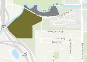
Red Cedar Natural Area - South
Location
Parking
Features
Publications & Reports
Kron, K. A., and B. S. Walters. "A study of Red Cedar Natural Area. I. Historical background and description of the vegetation." The Michigan botanist (USA) (1986).
Kron, K. A., and B. S. Walters. "A study of Red Cedar Natural Area. II. Checklist of vascular plants." The Michigan botanist (USA) (1986).
Han, Ho-Yeon, Ro, Kyung-Eui and McPheron, Bruce A. (2006). Molecular phylogeny of the subfamily Tephritinae (Diptera: Tephritidae) based on mitochondrial 16S rDNA sequences. Molecules & Cells (Springer Science & Business Media BV) 22.1.
Pielou, W. P. (1957). A Life-History Study of the Tufted Titmouse, Parus Bicolor, Linnaeus. Michigan State University.
Reemts, Charlotte Murray (2005). Temperate deciduous forest fragments: edge effects, invasion by non-native plants, and long-term change in mature forest structure. Dissertation. Michigan State University.
Ward, S. (2024). Red Cedar South Natural Area Bio-inventory Report. Michigan State University.
Zak, D. R., & Pregitzer, K. S. (1988). Nitrate assimilation by herbaceous ground flora in late successional forests. The Journal of Ecology, 537-546.
Zak, Donald Robert (1987). Landscape patterns of intraecosystem nitrogen cycling. Dissertation. Michigan State University.